 | SCOTTISH BORDERS |
THE WAVERLEY LINE TO WHITROPE TUNNEL
If you did as I suggested at the start of our walk and left your car at the Waverley Route Heritage Centre car park at Whitrope Tunnel, you now have an easy, interesting and in some parts spectacular walk back along the Waverley Line trackbed.

First item of importance that you might come to is the village rubbish dump, down the western side of the railway embankment just a hundred or so yards north of the village. For many years a series of informal "excavations" turned up abandoned family possessions that were either no longer wanted or presumably could not be taken out by train when families left.
All kinds of abandoned items have been discovered, from the original electric cookers supplied to the residents when the National Grid arrived in 1955 to old galvanised buckets to children's toys. A casual inspection in July 2008 by yours truly unearthed the remains of what looks like a 1940s-type of bicycle, and I have been shown other objects that were taken away by these amateur "archaeologists".

The rubbish dump is just by the side of the track that leads down to the former shepherd's cottage at Leesburnfoot. The area wasn't quite as uninhabited as some have suggested. There were two crofts in the area, occupied by shepherds and their families, although I have not been able to discover whether they were there before the railway was built.
Leesburnfoot is now a bothy used by hikers walking the Waverley Line and is maintained by volunteers from the National Bothy Association. I am told that is has been "improved" by the addition of relics and structures gathered from the site of the village. The second, now demolished, was known as Phaupknowe and was situated to the east of the railway track slightly to the north of here.

Back on the Waverley Line track bed we will be walking north-west and then north towards the famous Whitrope Tunnel. It's a comparatively easy walk provided that we don't encounter any timber lorries heading our way, as the track bed is used by contractors to the Forestry Commission, who haul out the timber on 40-tonne artics.
Their driving is the subject of much discussion and debate in the area and when the drivers are not expecting anyone to be coming their way and so are not paying any kind of attention (after all, it is a private road that we are on and we have no real right to be here) the results can sometimes be catastrophic, if not fatal.

Now, I have absolutely no idea what this might be. It seems to be some kind of building that has been well-overgrown by the local vegetation, so much so that it is unrecognisable.
It may well be a platelayers' hut, but seeing as how the old North Signal Box is only a cockstride away, that is debatable. In any case, I wonder if it goes back the full length of the bank that seems to be covering it.
I heard tell of an amusing story involving a platelayers' hut along this section of the line. One of the lengthmen went into the hut early one morning and in order to sit down on the bench had to move a pile of rags. The pile of rags turned out to be a sleeping tramp wearing all his clothes to keep out the cold. The surprise, shock and fright was, so I was told, mutual.

This brickwork is all that remains of one of the overbridges close to Riccarton Junction. If my calculations are correct, it is what was known as the "second bridge" and during the bad winter of early 1963 the snow filled the cutting here right up to the level of the bridge.
These bridges would formerly have been used by the shepherds and their flocks who were up here until comparatively recent times. The last of the sheep were removed from the fells in 1963 in readiness for the planting of the forest, which began in 1964.

While I was walking along here, I heard the sound of a considerable amount of running water at various places along the side of the old track bed, even though at first glance I couldn't actually see anything.
A closer investigation revealed that in several places there were springs bubbling up from the rocks in some of the railway cuttings. Just like this one in fact.

And just like this one too! There were quite a few, all told, and tradition has it that they were used to quench the thirst of many a railway lengthman, whose job it would have been to walk the line to check for defects.
And I bet they caused chaos while the line was being constructed too. Just imagine the scene with 100 navvies armed with pickaxes busily hacking their way through the rock here and one of them strikes the underground watercourse.

I mentioned at the beginning that parts of this walk would be spectacular. And I don't think that there would be anyone who would disagree. This photograph taken to the west certainly shows a view of that category.
It's impressive enough with all of the Sitka Spruce (it's either that or Norwegian Spruce) clinging to the top of the fells. Just imagine it 50 years ago when there would have been a clear view all the way over the top towards the Newcastleton-Hawick road and beyond to Teviothead.

Here we are at the remains of bridge 204 (I think that they are numbered from the Edinburgh end - after all, the line was built from that end).This is about a mile north of Riccarton Junction, at the beginning of another substantial and impressive cutting.
This is the Stichill Cutting and it's at this point that there is the tightest curve on the Waverley Line. Just looking at it you can see that it's quite impressive. Don't forget that this was formerly a main line with big engines and heavy trains roaring through here, not a branch line with a slow ponderous tank engine pulling (and sometimes pushing) single carriage.

The curve just seems to carry on and on as you can see in this photograph. I've walked to what seemed to be the apex of the curve when seen in the preceding photograph.
These deep cuttings caused havoc back in the severe winters, especially that of 1962-3. The wind whipping across the fells would pound the snow into the cutting and at times the line would be blocked completely. It was not uncommon for trains to be lost in the cuttings. The would be blocked by the snow, bringing a train to a standstill and then the wind would blow more snow in on top, filling the cutting and covering the train.

From roughly the same viewpoint as in the preceding photograph, here is a look backwards in the direction that I've just walked. Riccarton Junction is about a mile further back down there.
If you superimpose these last two photographs and orientate them around the central point then you can see precisely how tight the curve is here. Quite a few Pacifics (4-6-2) worked on this line in the age of steam and it must have been quite a sight watching one of them and a rake of 15 carriages come storming round here at 70mph. Not that many of them ever did. This part of the line is on such a steep gradient that a heavily-loaded train would be lucky to be doing any more than 30mph through here.

Well, at least I know where I am now. Only 65 miles to Edinburgh.
What is really ironic about the closure of the railway line here was the excuse that was given - that it duplicated the Edinburgh line via Carstairs Junction. Leaving aside the fact that of course it didn't, I have to comment that in every article that I have ever read about the closure of the Waverley Line I haven't seen a single suggestion along the lines of "well, why don't they close the line via Carstairs Junction then?"
And there are two good reasons why they should have done so.
Firstly the Waverley Route served a population of probably more than 100,000 people, many of whom lived in isolated communities such as Riccarton Junction. The line via Carstairs Junction served precisely no-one. There was not one stop along it once it left the Glasgow line. It was said that the passenger income along the Waverley Line wasn't sufficient to keep the line open. Well, the passenger income along the Carstairs Junction line was even less, and I never saw that argument used, either.
Secondly the Waverley Line is actually a couple of miles shorter than the route via Carstairs Junction.

This is quite an unusual and welcome sight. It seems that the Forestry Commission is taking seriously its responsibilities towards conservation and the environment.
It's extremely interesting that the Commission has appointed one Sarah Oakley as Conservation Ranger for its property on the Scottish Borders, and one assumes that all comments and complaints about the Forestry Commission's "practical" environmental policy may be addressed to this good lady who, we hope, will investigate them and deal with the matters arising.

And here is the reason why. Apparently we have a butterfly - the small blue - from the area that has become extinct around here due presumably to the interruption of its food supply.
Unfortunately the sign isn't dated so we don't know when it was erected. And so we don't know when "next year" might be, when the area is to be resurveyed to see whether the policy was successful and if the small blue butterfly did in fact return here.

Yes, I was right earlier. The bridges are numbered from the Edinburgh end for we have now arrived at bridge no203.
But what is that that we see in the distance? Stacked timber at the side of the track bed in the conservation area where it is forbidden? Surely not! Does Sarah Oakley know anything about this? If not, then I think she should be told!

Now if you look very carefully at this photo you will see one of Sarah Oakley's signs at the bottom left hand edge. Just to remind you what it says, it asks drivers not to turn round or drive over the verges and laybys by these signs. Now unless my eyes deceive me, there are tyre tracks in this layby and it's quite clear that someone has been turning round in it.
The sign also requests that timber should not be stacked on the verges or in the laybys. Well, you can see precisely what the Forestry Commission's "practical" environmental policy is, can't you?

You can also see what the Forestry Commission's contract drivers think about the signs too. And I also mentioned to you about the standard of what is called "driving", although I don't know why they call it that seeing as it bears so little resemblance to what other road users call "driving".
Here is one of Sarah Oakley's signs asking drivers not to drive on the verge where the rare kidney vetch might be growing, and a truck driver has quite clearly flattened it by ... er ... driving on the verge. Accident or design? Either response is unnerving. Perhaps instead of having the signs, she should employ people to read the contents to the lorry drivers. For the intellectuals amongst them (and hey, I've done truck driving in my time and I still have my Class I HGV licence) she could draw pictures.
And, of course, we have the standing timber on the verge that Sarah Oakley asks not to be put on the verge.

In her signs, Sarah Oakley also asks that tanks should not be stored on the verge or in the laybys. Well, this is clearly okay for it isn't a tank, it's a drum. And it isn't stored on the verge or in a layby, it's been thrown into a watercourse.
Just looking at it, you can see that a group of Forestry Commission lorry drivers have been playing truck hockey with it, and it's ended up out of bounds (but a real trucker would drive over that bank to push it back into play) but I wonder how much of the oil has seeped out to pollute the water course that drains into the verge onto which Sarah Oakley is desperately trying to grow the kidney vetch so that the extinct small blue butterfly can make its dramatic reappearance.
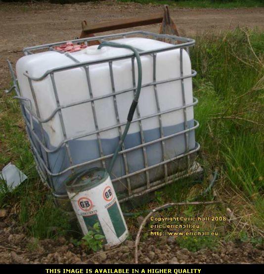
This if course is a tank, and a pallet tank at that too. And judging by the hose that's attached to it, I bet it has diesel in in. Mental note: next time I come this way, come this way in Caliburn. He runs on diesel of course.
And just have a close look at the hose. Just dumped down on the floor into a water course so that all of the diesel is seeping out to pollute the water course that drains into the verge onto which Sarah Oakley is desperately trying to grow the kidney vetch so that the extinct small blue butterfly can make its dramatic reappearance.
So having seen Sarah Oakley's best efforts at conservation and the environment, which probably won the Forestry Commission some kind of award from some group of gullible judges somewhere, we see the Forestry Commission's "practical" conservation and environmental policy in a conservation area, that wins no prizes but is out of view of the gullible judges who, of course, don't actually get out of their armchairs to have a look for themselves.
And neither does Sarah Oakley, by the looks of things. Conservation Ranger she may be, but I bet it's a while since she's been riding the range around here.

A little further on is another spectacular view, not of oil drums and timber stacks, but of the countryside to the north-west of Riccarton Junction. It really is impressive here and I reckon the isolation has a lot to do with that.
And in the distance perched on the outcrop over there would seem to be another blot on the landscape - a shooting hide. I hate hunters. If they were starving and it was all the food that they could get then fair enough. But wanton and indiscriminate killing just turns my stomach. I personally reckon that anyone who has a driving ambition to own a firearm should be immediately conscripted into the Armed Farces and find out in a practical experiment exactly what it's like to be on the receiving end of one.
But on a more positive note, you can see how misty it is - and it's the middle of July!

It's just here on the Laidlehope Embankment that the line is at its highest above ground level. We are standing some 98 feet up. The view here is looking more-or-less due westwards towards the Newcastleton-Hawick road, even though you can't see much because of the spruce trees. It must have been magnificent here before the planting.
The brook is only small but you can tell how much of a raging torrent it can become by how it has eroded away the bank at the extreme left-hand edge of the photograph.

This is the view eastwards, and it's even more impressive, especially as some of the trees have been harvested. When the remaining trees are harvested the view will be restored, but this woll only be temporary. The Forestry Commission has a tendency to replant the areas that it has harvested, but now that there is no mining industry to use the trunks as pit props, the Commission prefers mainly traditional broad-leaved trees such as oak and beech and the like.
The reafforestation programme in the UK began following the realisation during World War II that there was quite a timber shortage in the UK. Ships bringing timber across from Canada were easy targets for U-boats. But with the only war that the Brits are fighting right now seems to be one to steal the oil from weaker nations that don't have submarines to defend themselves, why didn't the Forestry Commission replant the area with oil crops and save the Brits from the inevitability of a humiliating defeat in Iraq?

Oh look! There's a track down to the culvert here from the side of the railway line.
I reckoned that it might have been something to do with the construction of the line 150 years ago when men would have to go down here to build up the embankment, but I've since been told that there used to be maintenance squads that would come down here every so often to work on it. My informant suggested that the line was abandoned in such a hurry (but there was an announcement some 2 years before the actual closure date, and 6 months notice was given of its final abandonment) that there were men repairing the brickwork down here, and on closure they simply downed tools and left.
For some while afterwards, so it is said, there were still the workmen's abandoned tools here. I was tempted to go down and have a look but the track hasn't been used (officially, that is) for 40 years. It was well-overgrown and something of a scramble to reach the bottom, and in an isolated situation such as this it's not the kind of thing that you do alone.

Mind you, the track did come in handy for another purpose. It seemed to be the best avenue of approach to reach the shooting hide. The shooting hide seemed to be well worth an inspection, so it needed a good plan.
Unfortunately, I misjudged my approach and ended up about 20 feet too low, so I had to scramble up from below in order to reach it.

It's a pretty rough construction, made from the facings of tree trunks that have been trimmed for manufacturing purposes, and just crudely nailed together with a plank of wood for a bench. One determined stag could tip this lot and its occupants into the culvert down below, and I would deerly "groan" - ed love to see that happen.
I wonder how many hunters would take up hunting if their prey were armed with similar weapons and the battle took place on equal terms? And these Americans get on my wick too with their Amendment to the Constitution about owning guns. Everyone else knows that it is a misprint, and that it was really intended to give every American the right to arm bears.

Meanwhile, back on Highway 61 .. er the Waverley Line track bed, we seem to be getting closer to civilisation, such as it is in the Scottish Borders. That gate up there marks the end of the Forestry Commission's right of way and we will soon be on the terrain of the Waverley Route Heritage Association.
That cutting up ahead is actually the Whitrope Cutting, 1000 yards long and the deepest part of the Waverley Line.

I mentioned at the beginning that the walk back to Whitrope was an easy one. Well, it is in the sense that the track is well-maintained and doesn't undulate like a traditional footpath over the moors. But nevertheless, there is quite a gradient here, as you can see looking back towards Riccarton Junction.
In certain places, such as here, the gradient is as steep as 1:75. In fact, the 8 miles between Newcastleton and the hump at Whitrope is an almost-continuous 1:75 ascending gradient. That is steep for a road over any kind of distance, never mind a railway, and a main-line railway at that. Even the massive Leeds-Settle-Carlisle line didn't exceed 1:100. It was no wonder that an engine shed was built at Riccarton Junction to house inter alia an engine specifically for the purpose of pushing heavy trains up here to Hawick.

I've managed to negotiate the Forestry Commission gate (you need to be careful as sometimes these might be locked and you will have to clamber over them) and am at the entrance to Whitrope Cutting.
First thing that you notice is that the road bed is in very good condition, unlike the Forestry Commission bit. I suppose that not having endless streams of fully-laden artics roaring up and down here might have something to do with that.

Here is a reverse angle shot, looking back southwards from the same point in the general direction of Riccarton Junction, which I estimate is almost two miles back down there way over the other side of the ridge on the skyline.
"Only two miles?" I hear you say. And probably not quite that far either. A great deal has happened to us during our walk so far and we haven't arrived at the end yet either.

"It's the deepest part of the Waverley Line" so I was told. And you can see that, looking at it in this photograph. This is some impressive earthwork, and it was carved (mainly by hand in those days) out of the solid rock.
We can't be too far away from the Hawick-Newcastleton road now, and so as this area was reasonably accessible it would have been likely that this would have been one of the first areas to have been worked. The added advantage of that is that the spoil didn't have to go far. It could simply be tipped into the gully to make the embankment over which we have just walked.
The traffic cone is exciting though.

The walling at the base of the inside curve here is interesting. Apparently there was some kind of issue with rockfalls and landslips into the cutting and on occasion it was necessary to station (well we are talking about railways here) a railwayman here to warn of rockfalls. Maybe the wall was built to replace the railwayman.
The dangers of trains running into landslips on the line was illustrated as long ago as 24th December 1841 ber when a train ploughed into a blockage in the Sonning Cutting, killing 9 passengers. Many railway companies put wires along their cuttings at a certain height. These wires were connected to instruments in the signal cabins and if there was a landslip, the distortion of the wire would activate an alarm.

That's another mile that we've chalked up today. Edinburgh is now only 64 miles away. At this rate we shall be there sometime round about Christmas 2010 if we are lucky.
But I'm more interested in the distance to the Waverley Route Heritage Centre, where Caliburn awaits. I had two packets of sweet biscuits and two litres of flavoured water with me when I set off (the importance of having energy-giving food and plenty of water with you on walks like this cannot be over-emphasised) and I've used them up. There's more water, a camping stove and some instant coffee in the back of Caliburn.

Looking back the way that we have just come, you can see that we seem to have acquired some police no-waiting cones on our travels. Not that there is likely to be anyone wanting to park along here, of course.
You can just about make out the milepost on top of the stone wall just above the nearest no-waiting cone in the centre of the photograph.
I'm told by the way that it is part of the long-term plans of the Heritage Association to run trains along here to the end of the cutting where the gate was. But the "long-term" of these plans was stressed to me. And the trains won't be steam-powered either. History records graphic examples of railwaymen chasing after brushfires caused by sparks from the engines - beating at them with shovels and so on. With all of the Forestry Commission timber around here, any kind of naked flame is definitely verboten.

And what is this that I see before me? Not a dagger of course, but a waste skip, or dumpster as they are called in North America. That can only mean one thing - that civilisation is close at hand.
If you have a careful look at the left-hand edge of the cutting you can see some other things that are interesting - namely a few lengths of railway line. Maybe the track-laying along the cutting is not as far away as one might think.

We are over the "hump" now, and from here it is downhill towards the Whitrope Tunnel that is about half a mile or so away. That means that the Heritage Centre is only a couple of hundred yards away.
There's quite an interesting set of relics here, many of which have caught my eye and not necessarily railway-related either. Just think of the fun that I could have with an old Ford Transit tipper, not to mention an enclosed shipping container (it wasn't a skip after all).

Mind you, the railway relics are quite important too. Especially this old snowplough. There were two snowploughs on this section of the line. One of them was based at Carlisle but I don't know about the other.
They were usually propelled by a pair of Stanier "Black Fives" coupled together tender-to-tender. With their combined power they would go full-tilt into the snowbanks and if they became bogged down, the engine facing backwards could pull them out, they would retreat a fair distance and start again.
That was the theory anyway. The practice was that on several occasions they became stuck and had to be dug out by the lengthmen. Eventually the lengthmen developed the technique of digging cuts across the snowbanks at every so many yards distance and this made it easier for the ploughs to clear the snow.
Mind you, I still prefer the snowploughs that I found on another one of my voyages.

We are definitely getting close to civilisation here. This below us is the road, such as it is, that runs from Newcastleton to Hawick.
Carole showed me what she contends to be the remains of an old toll-booth farther down the road here. That makes me wonder whether or not this was the old highway to Hawick before what is now the A7 over Teviothead. I'll have to see if I can track down a copy of R Bruce Armstrong's The History of Liddesdale, Eskdale, Ewesdale, Wauchopedale and the Debateable Land.
at a price that I can afford.
I did ask them at the Waverley Route Heritage Association about how they would fetch a locomotive up here. Just one look at the roads is enough to tell anyone that this would be problematic to say the least. The answer is that the low-loader or whatever it is that would bring the locomotive would come by road so far, and then drive up to the Association's HQ along the track bed of the Waverley Line.
Now how ironic is that?

The Waverley Route Heritage Association has its offices and exhibition in an old railway carriage, one of those that you can see in this image. Entry is by climbing in up a ladder, but it is well worth the effort and all donations to the Association are welcome.
And talking of climbing in up a ladder, there was no railway station here at Whitrope "you'll see how it develops" - ed. A couple of children who lived in the immediate neighbourhood attended the school at Riccarton Junction and of course when the school was open (it closed in the summer of 1962) there was no road (built in 1963) so certain trains were obliged to stop here to pick up and set down the kids. They too had to climb up and down a ladder.

Standing on top of Bridge 200, we can see some really beautiful scenery, as well as the Newcastleton-Hawick road passing underneath us.
You'll notice that the road is a single-track road with passing places (well, sort-of passing places. You don't want to be meeting too many timber lorries down here). Just let me draw something to your attention. When the Beeching Report was published in 1963, recommending a ruthless pruning of the railway network in the UK, it stated quite clearly that "In parts of Scotland ... road improvements ... may be necessary before adequate road services can be provided as full alternatives to the rail services which exist at present". You only need to look at this road to see that such "improvements" along this road were never carried out.
British Rail's solution was quite an interesting one. They routed the replacement bus service via the A7, Langholm and Teviothead some 7 or 8 miles away over some terrible roads. It was left to a private operator to run some kind of service between Newcastleton and Hawick. Riccarton Junction was ignored completely. Some replacement!
The local MP and erstwhile Lib Dem leader David Steel commissioned a study on the closure of the line - John Hibbs' "Transport In The Borders 1968". This concluded that Newcastleton would be the settlement most affected by the closure of the Waverley Route (poor Riccarton Junction was quite forgotten - its inhabitants were simply thrown out and packed off to Newcastleton or Hawick) yet nothing was done to resolve the issue.
The residents of this area had every right to be upset and angry. They were treated disgracefully and badly let down by British Rail and central government when the Waverley Line was abandoned.

Sometimes, you encouter things that are really quite poignant, things that make you realise that back in the "old days" people had a much greater respect for their work. In those days, many people reckoned that a job was for life and they stuck with it, regardless of the ups and downs that they encountered along the way.
This is a signpost for Whitrope Tunnel and its altitude of 1006 feet (307 metres) above sea level, but it's sad to see the other, more important notice underneath - for a railway engine driver from the area who had recently passed away and presumably wanted some kind of memorial on the line upon which he used to work.

Before leaving the Waverley Route Heritage Association's headquarters, it's well-worth a little stroll up alongside the railway line that the Association has laid.
In the old days, you could walk through the tunnel and out the other side. One person who did this recounted that she had seen three old cars abandoned in there. She didn't know what they were, but at least one may have been a Morris Minor. So nothing worth getting excited about.
But if it had been a Morris Oxford MO, or a BMC half-ton van, that would have been something else completely.

Today there is a fence across the tunnel to prevent entry - the reason being that the tunnel roof is unstable. Part of it apparently caved in fairly recently.
The fact that it wasn't until some 35 years after the closure of the line, 35 years without any care or attention at all that the roof caved in makes something of a mockery of the criteria that were applied to railway lines threatened with closure back in the 1960s. One of those criteria was that all major and essential maintenance had to be costed on the basis that it would be required to be undertaken within 5 years. And that with regular routine maintenance too!
When I talked to someone about the collapse of the roof inside the tunnel, that person expressed surprise. It is commonly said in the area that Whitrope Tunnel is a listed building of historical or architectural importance. I made certain enquiries on this point, and discovered that it is only the portals that are listed. The tunnel itself is not.
Some kind of costing has been undertaken with regard to putting the tunnel back into a secure condition for the passage of trains. The figure given was well into seven figures. That's a lot of money, you might think, but a mere bagatelle compared with what is going to be spent (and that remains to be seen, too) on restoring the Waverley Line from Edinburgh to Galashiels, that is going to start in 2009 (or maybe 2010, or perhaps 2012, or even as late as 2013, or ....).
And also a bagatelle compared to what it would cost to upgrade the road between Newcastleton and Hawick to the standard that should have been carried out before the closure of the railway line back in 1969.

The tunnel is 1208 yards long, and there are alcoves built into the walls for the railway lengthmen to shelter if they are inside the tunnel when a train enters. But these shelters are not evenly spaced or even very well-marked and there are several reported instances of railwaymen having to lie down in the "six-foot" between the two tracks to let a train pass by.
The tunnel was not very well-ventilated and smoke from the steam trains had a tendency to hang around inside. It was dangerous to move around when the smoke lingered and if the train had another locomotive attached to it to push it up the bank (as frequently happened) a railwayman could be trapped inside the tunnel for as much as an hour. However, trains coasting down the hill through the tunnel would suck out all of the smoke and clear the tunnel in seconds.
You would have thought that with the arrival of diesel locomotives, the problem would have been solved. But quite the reverse. The first time a diesel passed through the tunnel, a railwayman walking the track inside was nearly suffocated by the fumes.
So that is that, really. Riccarton Junction that was. But I'll be back again in early course as there are a few other things that I have in my mind to do.
©