 | CANADA |
LES ESCOUMINS AND LONGUE-RIVE
So having waved farewell to our fellow-travellers from 2011 who have sailed off to the southern shore, those of us from the journey of 2010 and that of 2012 can continue on our travels along the North Shore of the St Lawrence.

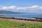
First thing that we need to check on is the town of Les Escoumins and there's a good view from a point up here near the petrol station, that looks as if it might at one time have been a former trace of Highway 138 before the recent modernisation programmes.
Of course we have to have an impressive church. No respectable settlement in Quebec would be without one. Its significance though is that the parish of Les Escoumins was the first to be founded along this part of the North Shore of the St Lawrence - back in 1846.

Here's a view from the modern road that, while the view of the town is nothing like as good, it gives you a good idea about the layout of the town and the bay just here, sheltered between the headland over there and the promontory from where the ferry to Trois Pistoles desparts
Although it might date from the 1840s, the town is said, with very good reason, to be the site of a Basque whaling centre called l'Esquemin (hence the modern name) that may well have pre-dated Cabot's "discovery" of what is now Canada.
The population today is said to be just over 2000, and its current interest lies in tourism. It is said to be one of the best places in the region to practise sea-kayaking and sub-aqua activities.
Something of a dive, you might say.
A short way outside the town is a headland called La Pointe de la Croix, so called because it has a cross perched upon it.

I would love to know the story behind this cross, as would many people because when a Jesuit missionary by the name of Father Henri Nouvel came here on 21 April 1664, he found the cross already erected.
Jacques Cartier was famous for erecting crosses at places that he visited, and while he left detailed reports of what he did, there was nothing anywhere to suggest that this might be one of his.
Champlain came here in 1626 and although he noted the presence of Basque fishermen and whalers in the area and the whale-processing plant that they had built here, neither her nor the Basques made any mention of the cross.
Nouvel seemed to be of the opinion that it might have been erected by the Amerindians from Tadoussac who had been converted to Christianity (and whose chapel we saw) and who were known to voyage along to here.
But one thing is for certain. I bet that Nouvel didn't find the cross festooned with electric lights like this one is today.

Continuing on from La Pointe de la Croix we come to some of the most stunning views to date of the St Lawrence River and it is really difficult to choose just one to show you exactly what I mean.
This one showing the rocks just offshore and the southern shore of the St Lawrence in the distance seems to be one of the best. And when I find a mile-marker I'll tell you where it is too but I haven't noticed one of those for quite a while.
Ahh yes - here we are. Mile-marker 622. It seems that they have surreptitiously moved the mile- markers - well, kilometre-markers, I should say - across the road.
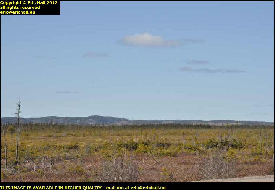
From here we leave the river for a while and climb a couple of hundred metres up onto the top of some kind of plateau.
You'll notice that the vegetation seems to have changed around here, almost as if we have moved into a different climatic zone. Gone are any traces of agricultural activity and it looks as if we might be moving into a forest area. All I can see are pine trees, with the Canadian Shield back there in the distance.

Of course no sooner do I say that but what do I find?
Quite right. Just here, someone has cleared away all of the trees to make some agricultural land that they are busily exploiting.
I had a quick look at the soil while I was here. To me, it didn't seem to be as rich as the soil that I've been seeing in other places along my travels. Being up here on the plateau, it's not recharged every year by silt that is deposited by the river during the spring floods.
As an aside, this is an unwelcome side-effect of the use of barrages for hydro-electric power. The river comes to a dead stop when it reaches the barrage and this causes the silt carried from upriver to be deposited behind the barrage
It's no longer reaching the farmland further downstream during the spring floods and so over a period of time, the farmland becomes poorer and the lakes behind the barrages are silting up.

Just after our farm we rejoin the St Lawrence River at the town of Longue-Rive - the "Long Bank".
That's quite an appropriate name for this town because it has a population of about 1300 and they all seem to live in one street that stretches for several kilometres along the shore of the St Lawrence.
The town being as it is, there isn't any one photograph that can show you all that there is to see of the important places here. You'll have to make do with a photograph that shows you one of the more picturesque spots.

Just after Longue-Rive (well, still within the town limits, so I believe) I threw out the anchor and came to a juddering halt. My eye had been caught be the most spectacular waterfall clearly visible at the side of the road.
This is in October 2010 and I'm pushed for time to make it to Labrador
before the weather breaks, but I can afford to take half an hour out of my schedule to look at this, especially as there is a car park handy.
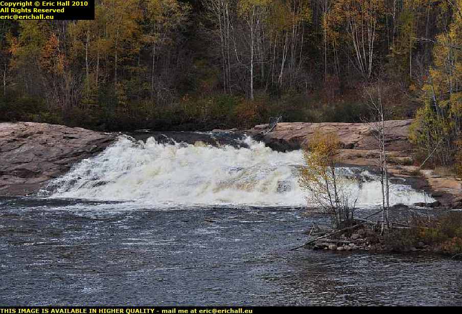
The river here is called the Riviere Sault-au-Mouton which in archaic French would be translated into "Leap-Frog River" in English. And you can see how the river earned its name.
Generally speaking (but not always, of course) waterfalls occur at the junction between two different bands of rock. The upstream band would be of harder material than the downstream band and so would withstand much better the processes of erosion. Over a period of many millennia this leads to a difference in levels.

That wasn't all that there was to say about the river either. I had a good look at the piers of the bridge and noted just how substantial the feet were.
Huge concrete masses in a substantial wedge shape. There must be some really big trees, rocks, lumps of ice and so on that are borught down here if they get wedges like these to deflect them away from the piers.
It gives you some idea of the force of the water.

Over on the other side of the bridge looking towards the St Lawrence, my eye had been caught by some other objects that looked as if they might be interesting.
Furthermore, there was a path that led down there and which took me over this very rickety-looking suspension bridge and it was probably worth going down there merely for the walk over the bridge.
And the photos of the waterfall dodn't seem to do it justice. You can see how far the drop is by looking at how far below me the river was when I was standing on the other side of the bridge, and how far down it is on this side.

I had to check out the suspension bridge of course - and here I am.
It cosists basically of a huge wire rope on either side providing the bracing for the bridge, and the deck is suspended from it. It's not in particularly good condition as you can see and it's swaying about rather a lot as I'm walking over it. I imagine that this would be a really interesting place to be when there's a strong wind blowing .

When I was up on the bridge photographing the waterfall and the suspension bridge, this is what I had seen and what had brought me down here. These concete stumps just here. It's exactly the sort of thing that would attract my attention.
You'll notice by looking at the skyline in the background just how far down from the road I am, and these concrete stumps went right back to the roadway up there.

Turning round and looking behind me, these concrete stumps continued on to the river where there were the remains of what might have been an old quay or a harbour or some such. Clearly, it used to be some kind of shipping point.
And then it became clear to me exactly what this might well have been, and my suspicions were confirmed when I arrived at Forestville a few more miles downstream because they have one there that is almost complete and you'll be seeing it in a bit.

So while you sit comfortably and admire the view of the St Lawrence and the shoreline, let me tell you a little story that concerns our concrete stumps.
And it also concerns a building that you will have seen if you came with me on my walk around the city of Quebec
- the Edifice Price, because this site has a considerable connection with the Price Brothers.

When we were in Quebec I mentioned that the Price Brothers were the prople who made their fortune exploiting the timber resources of the Saguenay region. They were, in their own way, some of the people responsible for the spread of modern infrastructure to the area - necessary of course to bring the people and machines in, and to take the raw materials out.
And this here was one of the sites from which they exported timber back in the early 1920s. I've already drawn your attention on a previous photo to the amount of timber that is available in the area.

Onto the scene entered the Clarke brothers, Frank and Walter. They owned a company, the Anglo-Canadian Pulp and Paper Mills Limited, which was based in their own town of Clarke City further down the coast neat Sept-Iles and which we will be visiting in due course.
This area passed into their hands and they began to export timber from here to feed the newsprint industry in the UK, the "Anglo" in the equation being Lord Rothermere, the British publishing tycoon.
And I haven't told you yet to what the stumps relate, have I? The answer to that is that they are the remains of an arboriduc, and if you want to know what one of those is, you'll have to come with me to Forestville and I'll show you one.
And furthermore, if you are a habitué of funfairs and the like, I'll bet that you've probably even been for a ride on one.
©