
|
CHEMIN DU ROY |
|
|
CHEMIN DU ROY |
OUR HERO EXPLORES THE INTERIOR OF CANADA
Leaving the ferry terminal at St Ignace de Loyola, I retrace my steps to Berthierville and rejoin Highway 138.

Just a cock-stride outside the town I encounter a set of major roadworks.
This is of course August 2013 (if you click on any thumbnail image and look at the upper left corner of the expanded image, you'll see to which year any photo relates) and when I was driving along here in April 2012 I recall there being roadworks on or around this spot back then.

I can't think what it is that's taking so long to fix, but it's taking almost as long as I have to wait for the traffic lights to change.
Many of these temporary traffic lights in North America (and one or two in Europe, I'm now noticing) have little indicators to tell you how long you have to wait for them to change.
This one is showing 184 seconds. It was actually at 200 seconds when I pulled up.

So having read the first half of War and Peace I can finally move off on my way to Trois Rivieres.
It all brings back many happy memories of 2010 when I was on The Trans-Labrador Highway and how I would one day love to re-do that journey, but in reverse.
I'd need a pretty sturdy gearbox though, and my neck would probably be as stiff as the time when I was with the much-maligned Percy Penguin (who doesn't feature in these pages half as often as she deserves) and I didn't swallow the Viagra quickly enough.

A short way further on, the Chemin du Roy turns inland away from the river and heads off through some nice agricultural farming country, dairy farming so I was informed. This is a really nice change for this part of Canada isn't it, seeing some traditional agriculture?
You'll notice the soil, though. It looks so rich, dark brown and really fertile from this point of view. But then again so it should. We're here on the flood plain of the St Lawrence and this soil will be all flood plain alluvium brought down from further up the St Lawrence, with maybe some amount of glacial silt brought down off the Canadian Shield.

This is the view of a section of the old Chemin du Roy just a few kilometres short of the town of St Barthelémy. One thing that you will notice in this photo and the previous one is the condition of the roads around here. Despite its importance 200 years ago, today it's just a quiet rural backwater and so it's not going to be maintained to the standards of a modern highway.
Another thing that you will notice here in this photo is something else that I've been observing for the last few miles as I drive along here on the Chemin du Roy out here towards Trois Rivières is that we are running along the foot of a steep bank to the north (in this photo, the right-hand) side of the river, and that bank is a good 30 feet high. We are a good couple of miles inland as well.
This would seem to me to be the old northern bank of the river from a long time ago. This could mean one of two things -
Firstly... that the river was so much wider back in those days and so there would have been so much more water flowing along. Whether there has been geological change that has diverted the flow of tributaries of the St Lawrence, or whether it's climatic change that has dried up the flow of water from further up the river, or whether modern river management techniques are responsible, I couldn't really say.
Secondly... it might be that the river is slowly shifting its course southwards and eroding away the bank on the far side of the river, depositing the residue here on this side.
If however it is the action of the periodic floods that occur on the margins of the St Lawrence you have to admire the power that the floods must have generated. To carve a 30-foot bank like this over such an enormous flood plain certainly takes some doing.
Certainly the builders of the Chemin du Roy must have been extremely wary of whatever the river might be capable of doing. They wouldn't take a detour like this, adding several miles to the length of the route and so much more to the cost of the road in order to hug the extreme edge of this plain without very good reason. In fact the road did in the early days run closer to the river but a few disastrous floods persuaded the planners to revise the route.

Next town along the road is St Barthelémy. This is another typical North American small town with the standard type of wooden houses with the traditional porch out on the front. It is however nice to see one or two people painting their houses in something other than the traditional white, and I wish that more people would take more of an effort to brighten up their surroundings.
This town of 2000 inhabitants is situated right at the edge of what I imagine is the flood plain rather than being right down on the river bank. I suppose that this is due to a long and bitter experience of the two hundred years of settlement in other towns along the shore of the river, and may also account for one or two houses having stone walls rather than wooden ones right at the ground level, and why one or two others are built upon stilts.
The town takes its name from Barthélemy Joliette, who founded the town that eventually became known as Joliette, not too far away from here.

No settlement in Québec is complete without the Catholic church, and this is one of the traditional "twin tower" designs of which we have seen, and will continue to see, innumerable examples.
Again, I've no idea of the name of the saint to whom the church is dedicated, but I would take a guess at the apostle St Barthélemy, or Batholomew as he is known in the Anglophone world, the patron saint of butchers, tanners and bookbinders.
I mentioned "two hundred years of settlement in other towns" and you are probably wondering exactly what I mean by this. This can be best illustrated by the story of the American tourist who came here one evening a few years ago, and he asked a local "when was St Barthelémy founded?"
"1855" replied the aforementioned
"Damn!" replied the American, looking at his watch. "Just missed it!"
The parish of St Barthélemy was however founded a few years earlier - 1827, to be precise.
All in all, my impression of St Barthelémy is that it's a terribly twee place, with antique shops galore and all that kind of thing. Not really my kind of place.

Next stop along the road, for me anyway, is the town of Maskinongé. Never mind the traditional wooden houses, the Catholic church or anything else of that particular nature - I was lured into the town by this really magnificent steel girder bridge. It really is beautiful and it's called the Pont Galipeault. There's a plaque on it dating the bridge to 1927.
I was impressed by the loading gauge on the road just before the bridge. This would seem to indicate that they have had issues on the bridge with high vehicles. What seemed to me to be bizarre is that the vertical supports for the height bar are set to the outside of the bridge. It would make much more sense to me to set them to the exact width of the carriageway over the bridge so that the whole assembly would constitute a true loading gauge. If you are going to be having vertical supports you may as well have them serving a useful purpose.
As for who the Galipeault might be, there was an Antonin Galipeault who was President of the National Assembly of Québec between 1916 and 1919 and who became Minister of Public Works in the 1920s. He was actually born here in Maskinongé in 1879. "Ah- hah!" I hear you say. "That's our man", but according to his official public record there are just two bridges named after him - one being a bridge on Autoroute 20 over the Ottawa River on the way out west from Montreal, and the other out on the Gaspé peninsula. Something is clearly not right.
We are of course along the Chemin du Roy just here and the river flowing under my feet right now is called, would you believe, the River Maskinongé. This, so I'm told, is Algonquin for a cetain type of pike that is found in here.

The first Europeans settled here round about 1700 although the parish was not created until 1855. But seeing that the Pont Galipeault was not built until 1927, how did they manage to cross the diligences - the stage coaches that travelled the Chemin du Roy - over the river to the other side?
Even though it is late April and so probably the peak period for water flow, I wouldn't fancy my chances crossing that river on foot by a ford or a rickety wooden bridge, let alone with a diligence.

There's some kind of weir up there on the other side of the bridge and the volume of water that is hurtling over there is certainly impressive. That will give you an indication of what the weather is doing further upstream. Melting piles of snow, I reckon.
However, you'll excuse me for thinking differently right now. I can safely say that Maskinongé is probably the coldest place that I have ever visited. Late April it is now, I am freezing to death out here and how anything can melt in this weather I really don't know.
Judging by the direction in which I'm travelling, having consulted The Lady Who Lives In The Sat-Nav and having felt the difference in and out of the wind, then what is blowing around here is a north wind direct from the Arctic and I'm not surprised that I'm so blasted cold. Bob Dylan wouldn't need a weatherman to know which way the wind is blowing around here - it's blowing right up the boulevard. I understand what they mean now by "perishing".
The Chemin du Roy brings me back to Highway 138 just outside Louiseville

I must have missed a turning in 2012 when I came down the old Chemin du Roy from Maskinongé because I ended up in Louiseville without very much effort.
In 2013 I took the modern Highway 138 between Bertheirville and Louiseville, and promptly stumbled across an old part of the Chemin du Roy that I clearly must have missed.

It's a good job that I saw this sign because otherwise I would have gone steaming past here. I just about had enough time and distance to shudder to a halt and turn down the old road. After all, it's why I'm here.
It's much more picturesque than travelling down the main road and brings back all kinds of ideas about how relaxing it must have been to have travelled down these roads back in those days, inclement weather and marauding Native Americans notwithstanding.

Judging by the looks of things, the state of some of the houses around here suggests that the houses were here first and they actually built the road around them.
There are more than one or two along here that need a couple of good coats of paint, and there are one or two that need, well, a little bit more than that. Any wooden building needs a good coat of paint or wood-preservative every 10 years or so. It's not something that you can put off.

With missing the one bit of the Chemin du Roy, I missed the second bit too.
When the deviation along the old road brings you back to the modern-day Highway 138, you don't rejoin the main road but go straight on over there across the level-crossing, as you can tell by the sign.
This route ends up in Louiseville right opposite the Tim Horton's outlet where I usually stop for coffee.
In 2012 I was freezing to death as a result of the bitter, piercing wind and so a pause for a coffee to warm myself up again was most welcome. However, in 2013 I pressed on along my route. I was unaware as yet that Tim Horton's now offered free wi-fi internet access to its customers.
Apparently Louiseville is exactly 100 kilometres from Montreal, but it's nothing like that at all if you have been following the route that I have taken.
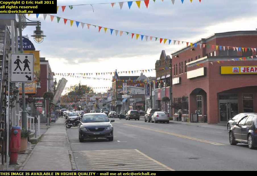
This is quite a busy little place (I say "little" but it has a population of 8000 and so it's a heaving metropolis by local standards). There are dozens of shops, crowds of people wandering around, hundreds of car-parking spaces and so on, and they seem to be preparing for some kind of fête or festival by the looks of things with all of this bunting.
The history of the place is pretty straightforward and would strike a chord with any students of medieval European history. In 1665 Charles de Jay, a former officer in the Carignan-Salières regiment about which we talked earlier and then the lord of the domain of Mannereuil, built a wooden fort here to secure the area against any possible First-Nation incursions and any enemy fleet that might sail up the St Lawrence, and over the course of time a settlement was established here, presumably to benefit from the protection that the fort might offer. This settlement was known as St-Antoine de la Rivière du Loup.
In 1880 the name of the settlement was changed to Louiseville, the Louise in question being the fourth daughter of Queen Victoria. She was married to the Marquis of Lorne, who had been Governor-General of Canada between 1878 and 1883, and had passed through here on the train. I'm surprised that, with this being Québec, they haven't reverted to the more Francophonic original name..
There's a couple of signs just outside the town. One of them proudly proclaims it to be the Home of Sarrasin, which as you all know very well, is buckwheat. In fact, the Festival de la Galette de Sarrasin - the Festival of the Buckwheat Wafer, takes place here in early October - just a week or so after I drove through here in 2011.
The other one gives directions to an Eco-centre and I reckoned that that might be an interesting place to visit. Or so I thought at the time. A few weeks later I found another Eco-centre right where I was stopped in Québec so I went to investigate, and it turned out to be nothing more than the local waste disposal point.
You are probably wondering why I haven't put as much effort into wandering around Louiseville as I have in one or two other towns just recently. The fact is that the temperature really has plummeted outside and with the bitter wind that's blowing right up the boulevard, I'll leave the wandering for another time. I'm bound to be back some time or other.
Before I leave the town of Louiseville, I was told that of the population of 8,000, almost everyone here is what they call tricoté serré, the literal translation of which is "tightly-knit". There is however a multitude of not-so-literal translations, apparently, but I didn't have the space to record them.
Anyway, leaving Louiseville I drove slap bang into the middle of an enormous queue of traffic. It seems that there's been a fender-bender with the police, fire engines, ambulances and all that kind of thing in attendance.
While I was waiting, I burst into poetry
"Mary had a little lamb"
"She wrapped it up in bunting"
"The little lamb made such a noise"
"She kicked ..."
but before I could finish my opus I noticed that the Chemin du Roy was signposted off to the left. If I hadn't have been delayed by the accident I would have gone steaming past that sign at a rather rapid rate of knots and probably disappeared up the back of my own beyond. It just goes to show that it really is an ill wind that doesn't blow anyone any good.
The Chemin du Roy takes me off inland again, away from the coast and along the edge of what I'm going to call from here on in the flood plain. It's another one of these merry, mazy roads.
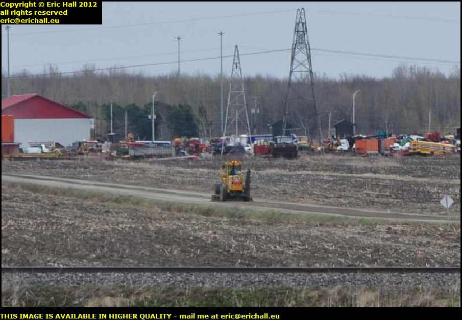
Those of you who came with me on my epic voyage along the Trans-Labrador Highway in 2010 will immediately recognise what that is down there. We've seen quite a few of those in our time.
We can also see a few redundant school buses down there, waiting for someone to find a use for them. Regular followers of this rubbish will already have seen a whole variety of examples of other peoples' uses of a redundant school bus. Are we up to number 85? I've lost count.
We aren't on our merry, mazy road for very long. We soon drop back down onto Highway 138 and straight away I miss a ship on the St Lawrence. I couldn't find a decent spec close enough to the river, being crowded out by half a forest and all kinds of other things too.
©