 | CANADA - |
BACK TO HIGHWAY 138
Just a short way outside Petit Saguenay, there's a signpost to the Village aux Vacances and so I wander off to have alook to see what that's all about.

13 kilometres down the track, and which is not a very good track either as you can see, this is what I encounter, as you probably might have guessed.
That's right, the tourist season has not yet officially started (I am, apparently, an unofficial tourist) and so the place is all locked up and deserted. There's nothing left for me to do but to turn round and drive the 13 kilometres back to Highway 170.
And turning round is not so easy either because there isn't anwhere to turn. It takes me 5 shunts to do a complete U-turn in order to face the other way. And as I'm doing that, I'm thinking to myself that a sign placed by the proprietors of the Village aux Vacances in a visible position at the turning off from Highway 170 explaining that the site was closed would have saved me all of this, and 26 useless kilometres to boot.
Anyway, as I have said before, this idea of just a three-month tourist season is a total nonsense, if you want my opinion. During those three months, there's an enormous amount of pressure on the tourist facilities and many people are disappointed.
These days there are plenty of retired and early-retired people, many of whom have plenty of money and have mobile homes with better facilities than they have at home, and they are looking for things to do.
Opening up the tourist venues and the camping sites earlier in the year and prolonging the season would attract them in hordes, given the right kind of marketing and they don't care what the weather is like as long as they have a good heater and a view of the Fjord?
The marketing by the Quebec Tourist Board - and many others too - is hopeless. Here where I live , there's a very active tourist board but again there's just a three-month tourist season, simply because the people who staff it are nothing more than University students on their summer holiday.
Actually spending a little money and having a full-time marketing officer with the necessary aggression, running the tourist season from 15th March to 15th November, it will pay for itself in spades.
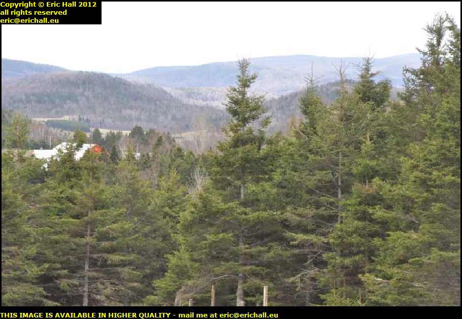
So leaving aside yet another really good rant, let's continue our drive along Highway 170 to kilometre marker 49 (that's 49 kilometres from Highway 138) and stop to admire the view.
On the left-hand edge of the image just above centre is the road down which we've been travelling. The views of course are quite spectacular, especially now that the rain has stopped and the sky is clearing. There's even just a little hint of blue sky in places.
However, there's now this unpleasant howling, freezing wind that plagued me for much of the earlier part of this adventure along the St Lawrence, and that makes me think that we might have passed over the watershed to the Saguenay Fjord and are now in the St Lawrence catchment area.
While we're here though, I want to go back to something that I mentioned earlier this morning.
If you look at the mountains here, you'll see how rounded the tops are. There's not a jagged peak in sight. This is, as I said earlier, a good sign of glacial action, with all of the jagged peaks eroded away by the glaciers.
Going beyond there for a moment, this implies very strongly that the glaciers must have been higher - and hence thicker - than the peaks of the mountains if they were able to erode away the peaks like this, and then going yet another step further on, just think of how much water must have been contained in the glaciers so that they were so high and so thick.
The amount of moisture on the planet is fairly constant. It's not possible for water to be added to, or taken from the planet in any kind of quantity over the timescale of which we are talking. Consequently, if there was all of this water in the glaciers around the northern part of North America, then there must have been so much less water in other places.
Petrified trees and all kinds of other prehistoric stuff are regularly being dredged up from the North Sea between the UK and Eastern Europe, and scientists are quite confident that at one time the sea bed was dry and that there were forests and rivers and all that kind of thing there, not to mention human settlement judging by the artefacts that have been recovered.
Furthermore, look in the Mediterranean off the coast of the mainland and the coasts of many of the islands there. All kinds of human artefacts, even down to complete palaces and cities, are there to be seen plainly by anyone with any diving experience.
All kinds of explanations have been put forward to account for these regions now being well-submerged, but surely the simplest one is to explain it all by the melting of the glaciers. Once the water is released from the glaciers, it flows into the sea and thus raises the sea level.
With modern human activity leading to an increase in the rate of global warming, we'll be seeing much more of this in the near future and with already far too many humans on the planet, where is everyone going to live as rising sea levels flood the coastal plain where most of the cities are to be founds? And where are the crops going to be grown to feed them all?
Every now and again we come into a wide-bottomed glaciated valley with signs of agriculture with hay and ploughed land and all of this kind of thing, so the winter weather conditions can't be all that desperate around here really, can they?

Here's a splendid example of just that, only 3 kilometres or so further on from the previous photo. This photo here shows a complete rural agricultural environment that you wouldn't really expect to see in a marginal climatic zone like this.
However, I am brought down to earth just a little by noticing the enormous stacks of wood at the side of every house around here. There wouldn't be this much wood about if they didn't need it in winter.
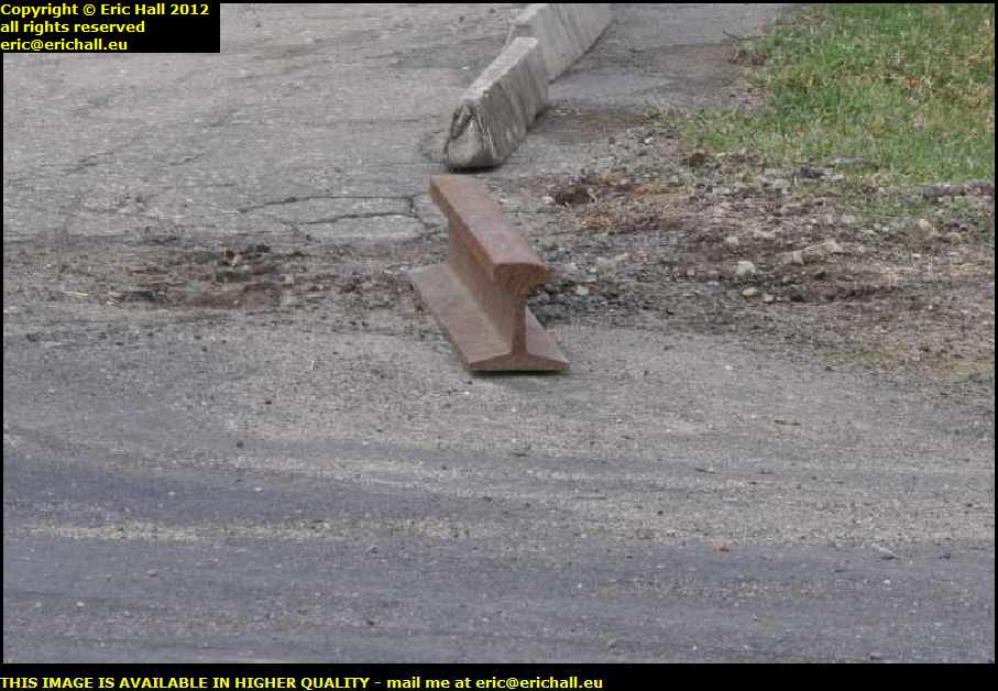
There's yet another old Jaguar parked up at the side of the road here and so I stop to take a photo of it, but I'm completely sidetracked bysomething else that catches my eye and I forget about the Jag completely.
I've noticed the length of railway line there being used as a kerb marker. There's only a couple of feet of it but seeing as we are so far away from the nearest rail yard, it makes me wonder how come it has arrived here.
It's the kind of thing that must have a story behind it and I would have asked someone, had there been anyone around here to ask.
It's round about here that I pass a sign informing me that I am now back in the region of the Charlevoix. So well done me, and welcome home.
At 11 kilometres from Highway 138 we come to another halt, this time at lac á Jean - John being evidently quite a popular name around the Saguenay.

This is right by some kind of mountain adventure centre called Les Palissades and just by looking at those cliffs over there, which reach to a maximum height of 244 metres, I bet that some of the visitors to Les Palissades have had quite a few adventures, what with one thing and another.
But look at how the weather is changing. The mist has gone and we are being treated to a nice sunny day. I hope that it keeps it up.

Merely 3 kilomtres from Highway 138 and we have our first glimpse of the St Lawrence River since we left it behind at Tadoussac about a century ago. You can see how far I've had to walk from the Dodge - and uphill too - in order to take this photo too.
As I have said before, finding safe places to pull off on the side of the road in North America is next-to-impossible and one has to make this kind of effort. I hope that you are all grateful.
You'll notice the cloud bank in the distance. The bitter north wind is pushing the air southwards, and that air is saturated with humidity after yesterday's bad weather.
The air needs to rise up over the south bank of the river and the Appalachian Mountains in the distance and as it does so, it cools down due to the increase in altitude. This causes the moisture in the air to condense, hence the cloud formations.
On that note, we end our glorious few days around the Saguenay Fjord and the Lac St Jean. Just down at the foot of the slope we rejoin Highway 138 and continue on our journey east to Natashquan.
©