 | THE TRANS-LABRADOR HIGHWAY 2010 |
THE LABRADOR COASTAL DRIVE PART V
And so that was Mary's Harbour. The next place that I am aiming for is Point Amour and its famous lighthouse, although that is not to say that I am not going to be sidetracked on my way.
Back at the hotel earlier this morning, some guy that I was talking to warned me that the southern road down to Red Bay is the worst part of the Highway. It was kind of him to mention it but if it is anything like as bad as part of the road between Churchill Falls and Goose Bay then it has to be something spectacular. I was a-quiver with anticipation. He also mentioned that someone else had seen a bear up here yesterday. It would be exciting if I could get to see another one today after meeting Rupert on his way to the picnic up on the new road the other day.
And so back onto the main highway with 125.5 kilometres showing on Casey's tripmeter. And those of you with long memories (i.e from yesterday late afternoon) will recall that I forgot to note the reading when I turned off. As a consequence, the kilometres for the exciting points of attraction along here will be given as (Casey's tripmeter - 125.5).
The first thing that I catch a glimpse of is one of these little compounds at the side of the road. It's fenced off from the surrounding land by a ... errr ... fence, and there's a Canadian flag growing ... errr ... flying in it. I'm determined to find out what these are all about (and I did too, when I was on Newfoundland)
A couple of kilometres further on - at 3.5 kilometres in fact, I encountered a sign to the Black Hills Ski Trail. It's a flaming long way to Dakota from here and so this must be quite a respectable ski trail. But seriously, I suppose that the inhabitants would do a lot of skiing around here with the weather and all the snow, and not much other possibility of moving around.
Ahhhh - hang on a minute. Here's a mile marker. Kilometre 160 on theirs is 130 kilometres on Casey's tripmeter. Now I recall that when I saw a mile marker for 290 kilometres, that was 31.6 kilometres along the highway from the far end. That makes this point to be 161.6 kilometres along the highway and so with Casey reading 130 kilometres at this point I can simply add on the excess over Casey's 130 kilometres to the figure of 161.6 to give a revised reading.
The first settlement that I come to is Lodge Bay, situated on the St Charles River in a quaint little bay. It's at 6.9 kilometres after rejoining the highway. There's fuel here too, a small shop and a couple of other interesting things worth noting, even though I forgot to note what they were.
But it's quite significant that with two settlements, each with facilities, so close to each other and the closest that two settlements have been since leaving Baie Comeau and probably a good while before there as well, it's an ominous sign that civilisation is drawing closer and closer.

A short way further on is a sign telling me that there is a gate and that I should be prepared to stop. Hmmm - not likely to be a cattle grid up here, I wouldn't have thought. I can't even remember when was the last time that I saw a cow.
Ahh yes. Road closed when lights are flashing. Do not proceed beyond this point. I suppose that this is what happens in winter. Someone comes along to block off the road to prevent people venturing off into the wilderness.
But that's also significant. Further back along the trail there was nothing like this and so you might think that traffic was free to move as it liked regardless of the weather. But it's more likely to be that the winter conditions are so extreme that no-one would give the idea of moving around in a wheeled vehicle the slightest thought. Here, conditions down in the valleys such as this one might encourage people to be driving around and thinking about heading southwards in the snow.
But this gives you something of an idea as to what the road is going to be like further on if they are worried about it in winter. High! No wonder the guy in the hotel warned me about the road.
You are probably wondering what you might be obliged to do if you arrive here and the gates are closed. The answer is that you go back to whence you came, build yourself an igloo and go off hunting seals until late spring. That isn't really much of an option if you have a hire car and there's an aeroplane waiting for you. You need to plan quite carefully the timing of your voyage.

So while I was stopped to take a photo forwards, it's also a good idea to take a photo backwards so that you can see the hill that I've climbed to reach this spot. Isn't it pictureque?
Mind you, the bright and gorgeous weather is contributing to the pleasant day, even if the ubiquitous power lines crowd the image a little. I'm still surprised that I haven't seen any village-cooperative wind turbines around here. There's been enough wind along the coast around here to blow me about.
Almost immediately, at 8 kilometres, there's a road sign. Now what does it say? Dum de dum dum - Ahh yes - Red Bay 78 kilometres, L'Anse au Loup 132 kilometres and Forteau at 144 kilometres.
You are probably wondering why all the names along the southern shore of Labrador are in French. I know that I was, and so I did some research.
It actually relates to a condition in the Treaty of Utrecht in 1713 which expelled the French from Newfoundland yet guaranteed French fishermen the right to fish around the Strait of Belle Isle. The French quickly took up residence across the Strait in Labrador, which had remained a French possession, and a fishing boat was quickly assigned to each of the bays during the season and to return each year. Generally speaking, the bays are named after the boat that took up station in it and if a settlement became established it generally took the name of the bay.
Labrador fell to the British in 1763 after the Seven Years War and although Labrador was declared off-limits as regards the fishing rights of 1713, it was hard for the British to police the coast effectively and even 100 years later there were complaints about French fishermen operating unofficially out of Labrador. The French fishing rights of 1713 were extinguished by a convention signed in 1904, by the way.
Now this road is pretty bad and I can understand why I was warned about it. I'm doing about 60 kilometres per hour and I don't really want to be going too much faster than that in certain places along here. Having said that, its nothing like as bad as the road over the top between Labrador and Goose Bay, that's for sure.
Another reason why you don't want to be going too fast along here is that you are never sure who is going to be leaping out of the undergrowth. It's growing pretty close to the road with here. Those of you with long memories will remember back in 2003 that I did have an encounter with a moose-like creature and I was lucky on a road in New Brunswick.
At 16.2 kilometres the road improves quite a bit and you can go faster along here if you like. I'm doing 70 kilometres per hour along here, which is the legal speed limit by the way, but I did go down to as low as 50 kilometres per hour a little further back.
It didn't last long though, and in the time it took me to dictate those notes above we'd fallen back onto the rocks again. And then at 21.5 kilometres I'm climbing a steep hill and the road up here isn't all that bad at all. This might well be one of the quicker parts of the road.
At the top of the hill round about kilometre 25.5 I find myself in the middle of a U shaped bowl. There are no mountains to my left and so that's where I reckon that the sea might be, and I must be that close to the sea as well.
As an aside, the road through that little patch just here is abysmal. Now, how many words have I used so far as synonyms for abysmal? That's an interesting little challenge for you and I ought to have a competition to see which one of my readers can calculate the number. And while you are working it out I'm going to be looking in a really good thesaurus to see how many there are, because I will have exhausted all of the possibilities by the time I get to a metalled road back in civilisation.

Not too far ahead, somewhere like kilometre 26.5, I come across an abandoned quarry. And in there is one of these folding caravans. And so we all know by now exactly what we ought to be expecting to see in a moment.
As for these abandoned quarries, it's not likely that the stone from here has been exported very far. There's plenty of rock around here and plenty that is much closer to civilisation. In all probability the rock has been exploited merely for the building and repair of the road here.

And so did you guess right? Not even 100 metres further on is some kind of nissen (and OpenOffice insists on flagging up the word, wanting me to change it to Nissan) hut which will relate to road-building or road maintenance activities, such as the storage and maintenance of a grader or two.
You'll notice how modern and recent the building is. That must have some kind of significance, as if they are going to be doing some serious work on this section of the road. It's not as if it couldn't do with it.

At 29 kilometres this climb starts to becomer even more steep and at 30.8 kilometres I finally reach what for the moment must be the summit of this really long climb. It's really quite high here and so I'm not surprised that this road is liable to be closed in winter when the snow gets up.
Apart from the couple of small patches of stunted conifers that you can see, I'm above the tree line again. It has been a long time since I've been above the tree line, particularly as I'm going south-east towards the coast and neither north nor into the interior
The road disappearing off across the photograph to the right and over the crest in the distance looks exciting, but only from a certain point of view. From another point of view the road up here is appalling with rocks sticking up through the trail (trail? How did that creep in? Has the road deteriorated that much or is it me being fed up with travelling on this dreadful surface?) and I'm having to slalom myself around the worst ones to avoid doing any damage to Casey's suspension.
Up on the top are a digger and a bulldozer and one or two other bits of machinery. They aren't working on the road right now but maybe they are just digging out the worst of the loose stones around here.

This photo and the next one should be taken together as they form a panorama taken from roughly kilometre 34. This is a photo looking south from that point and you can see that I'm above the tree line here for all intents and purposes - nothing but dwarf stunted conifers here.
Doesn't this look just like anywhere in the Highlands of Scotland and up on the Yorkshire Moors and these kind of places? There are claims that there is somewhere on the coast of Scotland that matches somewhere on the coast of North America like a jigsaw piece and you can understand that this might be so when you compare the similarity between the climate, the scenery and the vegetation.

This view from the same spot is looking sort-of south-westish which is roughly the direction in which I am travelling just now. You can make out, just to the left of centre, the road away in the distance which I will be driving over fairly soon.
You can understand how it might be that the road would be impassible in winter. The winds round here are pretty strong, as I have already mentioned, and there's nothing here to break them. Neither trees nor mountains. High up as we are and with the amount of snow that is likely to fall, the wind will just white-out absolutely everything and there would be little possibility of clearing it without the wind simply dumping it back.
Just a couple of kilometres further on at 37.6 kilometres there's another road sign that crosses my path. Red Bay is 49 kilometres, L'Anse au Loup is 102 and Forteau is 114. And we also have a grader. How nice.

The trouble with graders up here is that it is all very well that they spread out the soil and level up the road surface but when there are these huge rocks protruding through the surface like they do around here, then grading isn't going to do anything at all.
If anything it will make things worse. Scraping the soil away will bring the rocks up higher and then the blade of the grader will just bounce off the rocks, and tear up the road surface, like it has here as you can see. What ought to be done is to tip a pile of gravel on top, spread it around and then compact it down. You will probably know that along the entire route from Baie Comeau which can't be too far short of 2,000 kilometres, I've seen just TWO
They've done that at a couple of places along the road but only the Good Lord knows when. But, almost as if someone has been listening to me complaining, a little further on we do go through a short patch - and it is a short patch too - of decent road. It doesn't last for long.

As I drive over the brow of a hill at 41.1 kilometres I see all of this in the distance. "What is all of this?"I wonder. Workman's hut? Transport Depot? Café? Airport? I dunno. It could be anything but what is for sure is that we will find out in a minute.
And it won't have escaped your notice from the foregoing that despite already being quite high up, we are still climbing into the mountains and it doesn't look much like we will be descending any time soon either.

And indeed, at kilometre 44.6 (I bet you are amazed at the quality of the images that the zoom lens on the Nikon produced in the previous photo) all is revealed and it is a huge construction depot.
There are clearly some people in the Newfoundland and Labrador Department of Highways with a well- developed sense of humour because as I can tell you from my own first-hand knowledge and as you have seen for yourself in some of these photos, it can't be anything to do with this road given the state that it's in, I'll tell you now.
What is exciting about this photo though is that if you look closely at the hut that is the office premises, you'll notice the solar panels on the back facing towards the sun. And they are inclined at the correct angle too, which is even more of a surprise. And here I was complaining about the lack of wind turbines too.

At the side of the construction depot we can see the tubes that they use for bridging gullies and streams. What they do with the tubes is to throw them down into the bottom of a ravine so that the water can flow through them and then pile loads of stones and earth on top to build up to the level of the road at either side of the ravine so that there's an embankment for traffic to cross. It's cheaper and quicker than building bridges.
But do all of these tubes mean that there is going to be some more road-building around here? Or does it mean that the existing tubes have corroded away and need to be replaced? I would have thought that the tubes would be galvanised at the least given the cost and disruption that replacing them every few years would involve, unless the acid leaching out of the peaty marsh is dissolving the zinc and then eating away the bare metal.

At 45.3 kilometres I happen to glance into my rear-view mirror and the view behind is such that it makes me stop and take a photograph. You can see where I've come from and you can also see where I've been. Bleak is not the word, is it?
The speed limit along the Trans-Labrador Highway is 70 kilometres per hour and there are indeed places where you need to be reminded of the fact. There are other places where a speed warning sign is superfluous. Like the road for the last ... ohhh ... ages, or so it seems.
Once I move off I find myself driving through some kind of cutting which is probably one that has been formed by at one time being used as a quarry or something like that. There's another cutting almost directly ahead and as I pass through the second I see a third one ahead of me. And here's a surprise - I can put my foot down between cuttings 2 and 3 cutting. Well, for a short distance anyway. The speed limit signs were certainly not superfluous then, that's for sure.
In the distance I can see the road curving away round to the right and it looks like we might even be going downhill shortly. And not before time too. It seems like I've been stuck up here on this plateau for ages.

The weather is still holding up, much to my surprise, and as the morning wears on the temperature begins to rise. By the time I reach kilometre 53.5 I'm ready to stop and stretch my legs. Just at the head of the lake here is a nice little parking space that would serve as a picnic area where you can pull up and eat your butty while gazing over the water.
Not me, though. It's a long way from lunchtime and I have a great many things that I need to be doing before the day is out.
In the photo you can see back along the way that I have driven to here. The road winds up and over the top of the brow of that hill just to the right of centre and then winds round the head of the lake as far as here. You will also notice one of the tubes that we were talking about earlier, passing under the road in the foreground.

In the distance there is an interesting phenomenon that you get to see every now and again. There's a whole series of small clouds that are mirroring a mountain range away in the distance.
There's a clear blue sky and hardly any cloud at all but the prevailing winds pushing along from over the sea have picked up some water vapour. The air has to rise up to clear the mountain range and this causes the air to cool down and so the water vapour condenses.
And as it happens, in a few days time we will be having a meeting with some of those clouds over there
.
"How do you know that?" I hear you say.
Well, I have read the script.
That photo was taken at kilometre 54.1 by the way and despite my optimism of a while back I am still on this flaming treeless plateau and it looks like I'll be up here for ever.
But to break the monotony, at 64.4 kilometres there's another one of these nissen huts for the road menders.
And to break the monotony even more, just a little way further on we find a sign of life. There's a pick-up parked at the side of the road.
It's always a good idea to stop and enquire of the driver if everything is okay - after all, you never know and if there is a problem you can be waiting at the side of the road for days. In any case, I was feeling lonely and so I fancied a chat.
We discussed the sleds that I had seen at the side of the road near to the piles of cut timber. They are indeed for collecting the wood ready for winter. The sleds are left here ready to load up and bring home, and that certainly tells you something about the weather around here that they do all of this on sleds.
On a day like this in weather like this in temperature like this, it is really quite nice up here. I wouldn't want to live here though, but all the same it would be a nice place to drive around if I had the time and they did something about the roads. It would be nice if they were a little bit better but you can't have everything, I suppose. It goes without saying that it would be a nice place to see in the winter but to come up here unprepared must be horrendous.
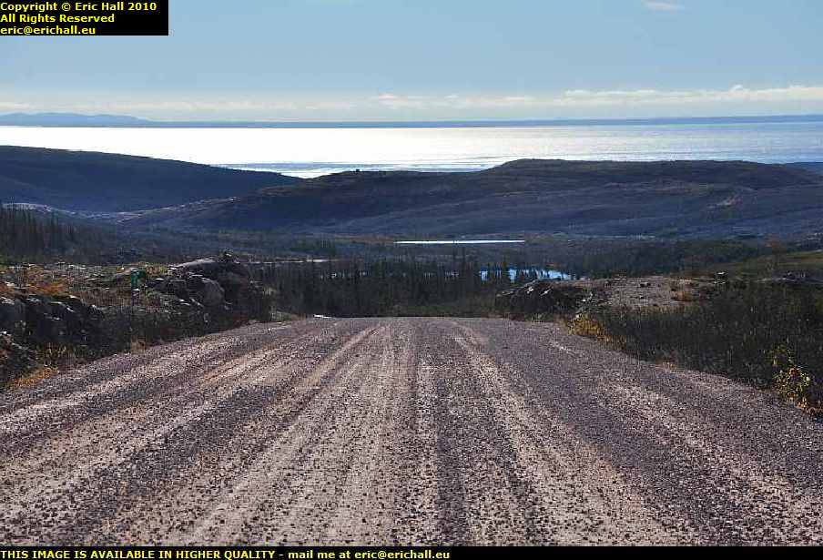
And I may be wrong but then again maybe I'm not, but at kilometre 67.9 I might just have caught my first glimpse of the sea. Not so much that you could photograph it but the road is still going on and on so there will be bound to be a better opportunity to take a photograph a little further on, I reckon.

Well, yes. Here we are indeed. This is kilometre 70.7 and this is the view. Underneath that weather front out there on the horizon, does that look to you like land in the distance?
If that is indeed land then that will be Newfoundland, so my folding little map tells me, and in front of it will be the Strait of Belle Isle, as immortalised by Archie Fisher in his album Windward Away and then if so my theory about Newfoundland and the Vikings may well be vindicated.
Actually, thinking about it, you might not be aware of my theory or the motivation that has driven me to this spot because, make no mistake, it is this spot right here that is the goal of my entire journey. And so I will explain.
A few years ago I wrote an article on the lost colonists of Roanoke Island and in particular the claim that Virginia Dare, born in the colony, was the first child of European origin to be born in North America. This was always the accepted standpoint, although there is evidence in the Norse sagas recounting the discovery of Vinland - now almost universally accepted as being somewhere in North America - that there was at least one child born to the settlers there.
I pointed this out, making the point that if the sagas relating to the discovery of Vinland are now accepted, then the ancillary statements and claims must likewise be accepted, something that many people are loathe to do, particularly when it comes to the case of Virginia Dare losing her status.
I was told that Newfoundland didn't count for North America, as it is an island. Now in that case, of course, Roanoke Island is what, exactly?
Anyway, the discussion rolled on and on, including the rather spurious argument that Roanoke Island isn't really an island as the mainland of North America can be seen from there. Of course I retorted that the mainland of North America could probably be seen from Newfoundland too - a fact vehemently denied by everyone else who has never been farther north than the Delaware River in the USA.
And so there you are - Newfoundland can be clearly seen from the mainland and so it follows that the reverse applies as well and my argument is vindicated. The things that I will do to prove a point.

As always, if I'm stopped to look at something forward, it's always worth a quick glance behind to see what the view is like back there.
Once more you are not going to be disappointed. You can see the way that I have come, and what passes for a road around here and there's a nice lake to tempt you to stay around here in the beautiful weather. In fact there are a few little lakes dotted around here and all of this is very pleasant up here, especially as I am within a cockstride of the sea.
So after the excitement of the sea and of Newfoundland, I can set off again. And I notice at 71.9 kilometres that I am back in real trees again. The climate is changing again now that I am approaching the sea.

And yes - is it that time already? Well, no it isn't, it's only just about 10:45 "ohh no it isn't" ...ed and there's a big old jet airliner passing overhead. Presumably it's come from Europe as I can't think of anywhere else that a jet of that size might have come from because there's nowhere else really west of here that would sustain a jet of that size "did you consider the Great Circle route over the Pole?" ...ed.
But its a bit early for that. The time slot for passenger flights from Europe over the Atlantic to North America is such that they won't arrive over here until later than this.
And so having mentioned "big old jet airliner" and being in a cheerful mood, I gave the aforementioned aeroplane a rousing chorus of the aforementioned song. But my best advice to you is not to listen to me singing it, and not to listen to Steve Miller singing it either, but listen to the writer, Paul Pena, singing it on his album New Train. It's much more impressive.
Now excuse the sun in the picture, but the sun does have to be directly in the lens of the camera and I'm not complaining because I am extremely happy to see it. But that is Newfoundland over there across the Strait of Belle Isle and there is no doubt at all about it.
It proves my point sufficiently does this, and goes to justify exactly what it was that I said right at the beginning.
What is significant about all of this is that I'm not too far short of ending my trip around the Trans-Labrador Highway. I'm really disappointed about that because I have enjoyed myself out here. Apart from the flaming prices, of course.
But then again, who am I to complain? I'm only here for a week or so. What about the people who have to live here all year round?

So I descend the steep hill, gazing at the Strait, gazing at the phenomenon of the clouds clinging to the edge of the coast of Newfoundland in the contrary winds that have trapped them, and also gazing at the ship that seems to be hugging the coast as it makes its way south-westward towards the St Lawrence estuary.
You will have noticed that the road has improved a little now. It's still pretty much ruts but there's loose gravel and everything lying about on it which hopefully will fill in the ruts in sooner or later. But still no compactor.
And there's a sign here. Red Bay. I'm stopping here as I have something to do - something which brought me the most extraordinary good fortune.
©