 | THE TRANS-LABRADOR HIGHWAY 2010 |
THE LABRADOR COASTAL DRIVE PART VIII - TO L'ANSE AU LOUP
And so much for Red Bay. That visit was certainly interesting. Now let's push on and find yonder lighthouse. I'm running really short of time.
I'm back on the highway, and a paved highway too, remember, with Casey's tripmeter showing 227.6 kilometres. I can't remember what it was showing when I turned off into Red Bay and I've driven around quite a bit during my stay there.
But all is not lost. There's a signpost here at 228.6 telling me that L'Anse au Loup is 51 kilometres away. It was 102 kilometres away when I was at 37.6 kilometres on the trail since Mary's Harbour, and so I'll set myself at this point so that I am at 88.6 kilometres.
That looks about right to me. I'll deduct 140 kilometres from Casey's tripmeter from now on for the next while.

So for the next few kilometres there isn't anything particular to see so I can push along a little, but at kilometre 95.7 I encounter the County Cat Pond. And if that is a pond then I would love to see a lake.
And as to the origins of the name, I've simply no idea. You'll have to work it out for yourselves. But I suppose I ought to run a competition for the most interesting or convincing answer.

Its just after the County Cat Pond that I encounter a sign warning me that blasting is taking place in the vicinity. And then I see the roadworks. They aren't going to put the road up there are they? Surely not.
According to Trevor Taylor, the Transportation Minister for Newfoundland and Labrador, $6 million is being spent on this section of road. The aim is to realign a section that is considered to be dangerous.
And I suppose that this means that no-one in his office has ever set foot anywhere further north than this particular point. I'm a tourist and I can show him plenty of parts of the Trans-Labrador Highway that are much more dangerous than this.
Mind you - I'm saying that but just 4 months after making his announcement about spending on the highway, Mr Taylor was handed his hat. So there!
Thinking about it further, that gate across the road at Red Bay isn't merely symbolic. It's maybe more to do with forming a barricade to keep the eskimoes and the "liveyers" out from underneath the feet of the politicians and keep them firmly in their place, while the Big People get on with spending the Government's money.
But having said that, it isn't just the Government that feels like that. A year or so ago I bought a second-hand copy of The Penguin History of Canada
, and I read it on the aeroplane coming over. And do you know? There's more history of Labrador on this webpage than there is in that book. In its 408 pages, Labrador is mentioned just three times.

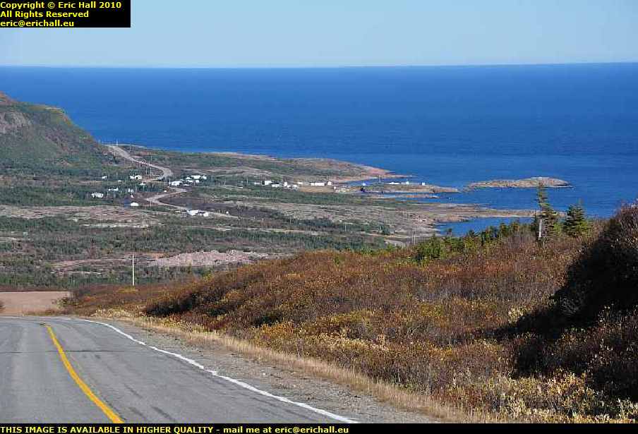
From the County Cat Pond and the road works I climb up out of the valley and into the hills again. There was quite a spectacular view behind me at kilometre 100.2 and it was worth a little pause for a photograph. It's a beautiful setting with a beautiful lake down there.
Another thing you will notice is that here I am, stopped in the carriageway just around the apex of a blind bend to take a photograph. There isn't the slightest possibility of me encountering another vehicle on this road, so I reckoned at the time. And I was right too.
And did I say "lake"? This is a river, I reckon. Lakes don't have ripples and currents like those that I can see just here at kilometre 102.8. And if you wait for just a minute I'm sure that there will be an excellent spot to stop and take a photograph so that you can all see for yourselves.

Rather like just here, in fact, at kilometre 103.3. There are some ripples in the foreground and even more ripples in the background too.
This is strange because the ripples seem to indicate that the flow of the ripples is following me to the south-west. Why isn't the river going down towards Red Bay and eroding itself through the mountains into the sea back there?
I would have thought that going that way would have been the quickest and easiest way to the sea even if the river would have to carve itself a little way through the rocks in order to get there.
Just a little further on I notice things that look much more like ripples. And a little further on I encounter gorges and chasms and all of that. There's even a small waterfall, but there's no real place to stop and photograph any of that because we have have high trees obscuring the way and I don't really want to go mountaineering down there for a closer look.
Something will turn up.

And at 106.6 kilometres something does indeed turn up. Not only is there an excellent view of the gorge but there's also a place to stop and photograph it. Now isn't that what I call a real gorge? It is the Pinware River down there by the way.
I can't conjure up a small waterfall for you though but I'm sure that you will be more than happy with these rapids just here. These are pretty good.
There's quite an impressive stand of timber down there as well. I suppose that the early summer meltwater floods bring down whatever soil is higher up and this creates some kind of fertile flood plain, or what would pass for a fertile flood plain round here.
Almost immediately I stumble upon roadworks again, but this time it looks like they are digging up after a rock fall. There is rock all over the side of the road around here, but of course this may well be the result of a pessimistic dynamiter. We've already seen an example of precision dynamiting in Labrador.
There's also the electricity board stringing up a new cable across the highway here. The thought crosses my mind that it may well have been the digger bringing the cable down with its jib while it was digging away some of this fallen rock, such cynic that I am.
The fitter is using a little hand-held winch to pull up the cable up. I have a couple of those at home. And while I was sitting here waiting for things to happen, one of these silly little animals with a long tail - the miniature squirrel-like thing - scurried across the road and once more I wasn't ready with the camera.
And it must be that time now - I'm starting to notice the jets flying over here from a Europe-like direction. It's European flight time then,

Excuse the bright sunlight here in this photo but at kilometre 112 there's an excellent view along the river bank that was well-worth a photograph.
If you look into the dead-centre of the photograph there's a really good view of a road of some description going up over some headland over there at the side of the river away in the distance. I wonder if that's where I'm going. I hope so, for I reckon that there will be apretty spectacular view from up there.
And just to reassure me, I'm told that at 1 kilometre from kilometre 119.2 I'll be coming to the Pinware River Provincial Park.

Around the bend at 119.5 kilometres there was quite a spectacular view in Casey's rear-view mirror, just as I had foretold. I just had to stop and take a photograph of it.
I've driven all the way up this hill from the foot of the valley miles away in the distance and it all looks really spectacular. A nice day, some beautiful scenery, plenty of trees and mountains. What more could anyone want?
Just half a kilometre further on is another roadmender's nissen hut. But I have now made a conscious decision that I'm no longer going to talk about this sort of thing. I'm evidently back in civilisation now, what with paved roads, Government ministers and so on and there are other more interesting and exciting things to see.
Like the sea for example.

At kilometre 121.1 I burst over the summit of the range just here and I find myself at the ocean. There are views and everything here right now. So I shall turn off to have a wander down a little side road to the bay to see what there is to see.
And here we are. From the bay there's a nice little shot of the village at which I'll be arriving imminently and so all I require in the immediate future is a nice little place on a cove or at the side of the highway, something like that, anywhere with a decent view where I can stop and make myself a butty. What with all of the excitement so far today I haven't had anything to eat yet.
I am back on the main road at 261.8 on Casey's tripmeter so I'll be knocking 140.7 off the subsequent readings to keep the mileage figures accurate.

The town that I photographed in the previous image is called West St Modeste and it's at 124 kilometres along the road. There's a handy verge on the left hand side of the road that is an ideal place to stop and eat my butty.
And this is the view from my lunch stop and very impressive and pretty it is too. Out in the distance that grey smudge on the horizon is the coastline of Newfoundland.
I've noticed here too that most of the houses have some dog-kennel kind of things just outside the front gates. I wonder what these are all about.
We talked about Wilfred Grenfell a while back when we were in Mary's Harbour, where I remarked upon his work out at Battle Harbour. As it happens, West St Modeste was the site of his second outpost and was opened in 1903.
And just while we are on the subject of Dr Grenfell and his missionary work amongst the Labrador seafarers, the Oblate Mission, which says that its missionaries "dedicate their life to serving and evangelizing the poorest of the poor and the most abandoned", chose West St Modeste to establish an outpost, called "Our Lady of Labrador".
Hmmmmmmm - "most abandoned". You can see that I am not the only one who thinks what I think about the gate behind Red Bay.
And just in case you are wondering, which I am really sure that you are, there is an East St Modeste. Or at least there was. It had a population of 37 according to the census of 1874 (and that was quite a number for those days) but only 12 in 1956.
However it's another one on a long list of Labrador localities that fell by the wayside as a result of the controversial resettlement scheme that began in 1954.
The next place of any note is Capstan island and the road down there from West St Modeste was exciting. Just after leaving the latter, at 128.2 kilometres I was confronted by this most magnificent, impressive headland. I would have certainly taken a photograph of it but at this time in the afternoon I had the full glaring sun at 100% right into the camera lens.
But not to worry. As soon as I can get beyond it and look back, I'll take a photo of it because the road looks like its going straight up and over the top and so that shouldn't be difficult.
And weren't they famous last words? I found myself hemmed in by a pile or two or rocks and I couldn't find a shot from the other side.

But by this time I had found myself in Capstan Island and so went for a wander around. The first thing that I noticed was of course the boats. This is another fishing port. The second thing that I noticed was that it isn't actually an island, and the third thing was that there was nothing in the vicinity to resemble either a capstan or an island either.
But then, I was informed, I had simply timed my arrival badly. There's a tidal island offshore somewhere and the residents had a capstan on there that was used to power some kind of seal trap that blocked off the migratory passage of the aforementioned so that they could be caught.

I didn't stay long in Capstan Island, because a settlement of less than 50 people is hardly likely to hold too much attention for a high-roller and dazzling urbanite like yours truly, and I was confronted by a similar kind of magnificent impressive headland as upon leaving West St Modeste.
This time however there was a good place to take a photograph that wasn't full-on into the sun, and you can see an idea of what these impressive headlands are like, simply by looking at the view from near the top. Actually, at 132.9 kilometres as it happens.

At 134.4 kilometres the road swings round a bend on another headland and the view of Capstan Island is even more impressive. I'm certainly glad that I stopped for this.
I was told that the soil around Capstan Island is the most fertile in the region. And it's probably for this reason that there is an enormous commercial greenhouse here. You can see it just to the left of centre. To the right of centre, on the shoreline, is a fish processing facility. I told you that the sea played a major role in this community.
And even higher up, at 135.2 kilometres, the view is yet more spectacular and you can even see the magnificent headland that caught my eye on leaving West St Modeste. That's it on the left of the photograph. And what a beautiful afternoon it is, too.
And so on setting off and leaving Capstan Island behind I had a little muse to myself - if the name of the village is taken from the efforts of the residents with the capstan, then there must have been residents here before the capstan and so what was it called then? Strangely enough, no-one had an answer for that.
And also as I pull away and climb even higher up the headland here I notice a sign "rough road ahead for 6 kilometres". I wonder how this is going to compare with some that I've been driving along, as most of them haven't been labelled at all.
The answer is, having waited until the end of the 6 kilometres before I made an observation, that I will trade any stretch of road that you like up on the High Labrador Plateau for any length of this rough road.
And during the 6 kilometres of rough road I notice a walking trail up here called the Battery. Ordinarily I might have gone for a drive but I'm struggling a little for time and I don't know that I can get Casey down there without some kind of time-consuming effort.

I finally reach the top of this headland at 136.2 kilomtres and right there we have an impressive array of radio and other transmitting aerials. And it isn't surprising to see them here either. I reckon that this must be one of the highest points right on the Labrador coast.
It's also a nice friendly touch to have a little car parking space here so that you can stop clear of the road and take a photo of the array. A sea view would have been nice too but I suppose you can't have everything.

Did I mention sea view just now? All I have to do is to drive half a kilometre further on and I can have as much as I want. The view from up here on this headland is just so stunning. You can see for miles right down the Labrador coast probably as far as the ferry to Newfoundland.
Well, I suppose you can in theory but in practice it's rather difficult because I have the sun right into the camera lens and you are lucky that anything has come out at all, let alone a coherent image.
And you can see what they mean about the rough road. But it's still not a patch on what it was like in Upper Labrador, is it?
Ever since leaving Goose Bay, and I can't remember how many years ago that was, I've been steadily following the signs for L'Anse au Loup.
And 579 kilometres (and a considerable number more than that as well, thanks to all of the scenic diversions I've been taking) later I finally arrive here. It's situated more-or-less at the foot of this headland, at 138.3 kilometres along the highway from my fuel stop at Port Hope Simpson.
L'Anse au Loup, or Wolf Cove in English, is actually a big town, the first big town (or what passes for a big town along the Labrador Coast) that I've seen for quite some time. There are over 600 inhabitants, so I'm told, and its population is increasing. That's something that surprises me, and for two reasons, both of which concern the Town Council.
L'Anse au Loup is definitely not my kind of town.
So enough of me complaining. Let me go back to the story.
Down at the bottom of the hill I burst into the town, and burst straight away into the blinding sun. No chance of taking a photograph in this and so I head for the other side of the hill, carefully noting anything of interest on the way, with the intention of photographing rhe town from the south with ths sun behind me.
It's clearly a place where all kinds of exciting things happen, so take no notice of me. There's a furniture shop for a start, and when did I last see one of those? That big shopping complex opposite Québec City, probably. I don't recall one in Baie Comeau. There's also a Sears outlet and the Labrador Straits Arena. Evidently a heaving metropolis.
And so out of the other side I drove, and do you know what? Anywhere with a view, there was no place to stop. And anywhere to stop, there was no view either. Ordinarily I would have parked the car and gone for a leisurely saunter about but running hours late, a lighthouse to visit and a ferry to catch, I just didn't have the time.
What I'll do instead is to tell you a little of the history of the town.
Following the expulsion of the French from Newfoundland by the Treaty of Utrecht in 1713, many French fishermen moved across the Strait to the Labrador coast, which remained in French hands until the end of the Seven Years War in 1763.
The French fishermen were granted rights by the French government for certain ships to occupy certain coves, and two boats were known to be operating out of this cove in 1717.
These rights, by the way, date back to a custom said by many to have been established by the British in 1582.
Having witnessed the free-for-all fighting that went on over fishing stations in Newfoundland and on the Coasts of Labrador, Sir Thomas Hampshire is said to have persuaded Queen Elizabeth to allow him to make a rule.
This rule was that "Whatever room or space of foreshore a master of a vessel selected, he could retain it so long as he kept up his buildings on it, and employed it for the use of the fishery".
And so the story goes according to some, although other people have been unable to trace either a Sir Thomas Hampshire or a voyage of 1582.
In 1748 the rights were awarded to one Joseph Deschenaux, and he was authorised to exploit the natural resources of the area - the maritime resources of course being the most important - and it is believed that the permanent settlement of the area dates from this concession.
In fact it is said that the boundaries of Deschenaux's concession correspond in the main with the town boundary even today.
Following the occupation of Labrador by the British in 1763, the more-mainstream traders and merchants arrived and a permanent trading post was established. Once a fish-processing plant was built in the town, its future was more-or-less assured.
But although the Treaty of Utrecht is generally considered as being the beginning of European-style occupation of the cove, it is quite easy to imagine a splendid site such as this being attractive to previous waves of Europeans.
It is suggested that there is documentary evidence to show that Basque whalers from up the road at Red Bay came here in the mid-16th Century, and others are certain that French fishermen were here before them and maybe even before Cabot's famous voyage of discovery.
Furthermore, archaeological excavations here have uncovered evidence consistent with the Viking way of life.
And so, on that particular note I put my foot down and head off into the wilderness again. L'Anse au Loup will have to wait until my next visit.
©