 | NEWFOUNDLAND 2010 |
TO CHANNEL-PORT AUX BASQUES
Back on the Trans-Canada Highway after my visit to Stephenville and I'm encountering problems straight away.

Hmmmmm - it looks like the bridge over Robinson's River has collapsed and they are having to rebuild it all - at least that's what it looks like from up here anyway. There's quite a deviation or diversion and a part of the "new highway" has to go off the edge of the metalled road, round and back on again.
There is a "pretty rough - drive very slowly" sign here too but I tell you what - it is nothing like as rough as what I was driving on over on Labrador a couple of weeks ago . Some people don't know that they have been born.
Come to think of it, there have been a few parts of this road that have been under heavy repair and I don't know what has happened. I don't think that Hurricane Igor reached this far and onto this side of the island

Ahhh - now I know what has been happening along here. Do you remember being with me along The Labrador Coastal Drive when I pointed out the metal tubes that were being used as culverts under road? And do you remember me saying that I wasn't convinced about the lifespan of those tubes?
It seems that I was absolutely right about that. Here's a pile of these tubes all stacked up at the side of the road and you can see just how corroded they all are.

In this photo just a little further on you can see where these tubes came from as well, judging by the strips of fresh tarmac across the road. It seems that there is some kind of systematic replacement of them all.
Mind you, I hope that they are replacing them with something much more durable that metal tubing. Concrete pipes would be the ideal thing to use for this kind of thing and I'm surprised that they haven't been using them here. The extra weight in the transportation isn't going to be the same kind of an issue here as it might be out in the wilderness on the ... errr ... less-good roads up on the Upper Labrador Plateau.
The road from Corner Brook to Channel-Port aux Basques is a sort-of reasonably mundane type of road. No abandoned vehicles, no ancient hydro-electric power stations, no steam trains or anything like that.
I suppose that in normal circumstances it would be quite nice and pretty but there is just so much of it that it's hard to focus on anything special, hence the comparative absence of photographs.

Every now and again though there is a section of the Highway that has some kind of stunning view, and it has a tendency to catch one unawares. As the road goes up over the mountains and slowly drifts down the coast towards the ferry there are a couple of places that particularly caught my eye.
This one is probably the best to date. It's a view up the valley into the Long Range Mountains, somewhere not too far away from South Branch River
Not long after I set off, I'm obliged to stop again as there is a house coming towards me along the road. You know what I mean - one of these houses that North Americans seem to live in that look like mobile homes that they move from place to place.
It wasn't travelling under its own steam, which is a pity - that would certainly have been exciting - but was on the back of a huge lorry heading my way. It was accompanied by a couple of out-riders who pushed the traffic over to one side so that it could pass.
It was a shame that it happened on such a winding road as this. Had it been on a long straight I would have had time to prepare the camera, as I did in Ontario all that time ago when I encountered that wind turbine.

If you were with me on the drive down along the Viking Trail from L'Anse aux Meadows the other day you will have seen plenty of views such as this one at Doyle's.
The Trans-Canada Highway is over there to the right of the photo of course but never mind that for a minute, I'm looking at the range of hills just here in the Codroy Valley. It seems to be typical west-Newfoundland scenery, this kind of thing, but it is quite beautiful all the same especially when the weather is nice.

The scenery seems definitely to be improving down here in the south-west corner of the island. I've hardly had time to start when I have to come to a dead stop again. In fact I'm only half a mile or so further on when I encounter this bowl in the hillside with the waterfall tumbling all the way down.
In fact it makes me wonder whether or not it might have been like this up on the Viking Trail but the weather was mostly so awful that it was very hard to tell.
I've taken a little detour off the Trans-Canada Highway because even though it's about 15:00 or so, I still haven't eaten my lunch
And while I'm on the subject of detours, let me talk about the flags here. You see them everywhere, on car licence plates, on houses, all that kind of thing, and I can't think why I never took a photograph of one because they are quite unusual. We have a tricolour of pink, white and green.
One of the original communities of settlers here used pink as their colour, and another community (the Irish, probably) had green as their colour. They were always fighting amongst each other "it had to be the Irish then" ...ed and after quite a while of this, the local priest became thoroughly fed up with it all. He took hold of a green flag and a pink flag, and tied them together with a white flag to indicate that he was surrendering, as he could do no more to bring peace to the warring factions. This was how the tricolour was born, so they say.

And so where I've come for lunch is to Cape Anguille, which, for the benefit of those of you who are interested, is 20 kilometres off the Trans-Canada Highway and the farthest westernmost point on the island. I mean, having been to the farthest easternmost point the other day, however could I miss out?
Surprisingly for Newfoundland, there is agriculture of a sort being carried out here. But then again, being in a bowl and sheltered on three sides from the freezing wind by mountains and open to the sea at the other, south-western side, it's a place that would have a great deal of agricultural potential as long as they keep on adding humus to the soil and they don't overgraze it.
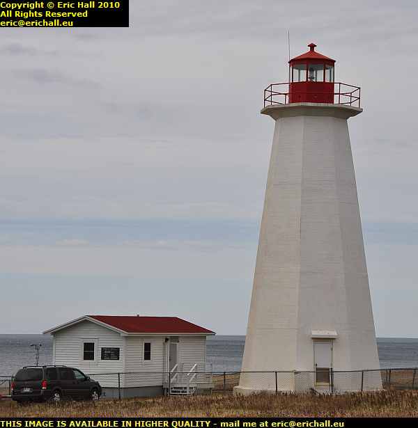
Being right at the corner of Newfoundland with the Strait of Belle Isle going up to the north and the Cabot Strait off to the east, the Cape could be treacherous for shipping leaving the St Lawrence River, and hence there is a lighthouse just here.
This one is not the original, being built in 1960 to replace the one of 1908. Rarely, for this part of the world, it's built in concrete and having travelled with me on enough of my voyages around the coastal areas of the world you will know that it has its own distinctive signal, to distinguish it from others in the dark. The Cape Anguille lighthouse emits a flash of white light every 5 seconds.
There's also a foghorn, but no-one around here could tell me if it was a compressed-air diaphone as we have been encountering at places such as Point Amour and Cape Race , to mention but two.
While I was here at Cape Anguille eating my butty, I took what can be best described as "a certain initiative". You may remember that back in St John's I bought a slow cooker, and when I was in Clarenville having Casey's puncture fixed I bought a couple of small inverters.
I'm noticed in Casey's boot that there was a cigarette lighter socket that only worked when the ignition was switched on and so I quickly put some pasta, some water, some vegetables and some beans in the cooker, plugged it into the inverter and plugged it into this cigarette lighter. As I'm driving around this lot will be cooking and I'll be interested to see what kind of meal I'll be having while I'll be waiting to board the ferry tonight.
We mentioned a short while ago about the historical associations of the area with different ethnic groups. You can tell everything that you need to know about this area just by looking at the names of the settlements. There's a town back here called O'Regans, I've seen a place called Dunphy's Pool and of course, we've had a Doyle's.
It's clear therefore that this area was predominantly settled by the Irish, yet you will have noticed that the prominent geographical features are named in French, Cap Anguille being one of them. That's because the French were the first here and so they named all of the most important geographical features along the coast and for the most part they stuck.
This is the case in many areas where the later arrivals have taken over. In the north of England, for example, despite the successive waves of Romans, Saxons and Vikings in that order, the major geographical features, such as Pen-y-Ghent maintained their Celtic names.
And why are there so many rivers in England called Avon? The Modern Welsh word for a river is of course Afon and hence the Caltic word for river would have been more-or-less the same. You can imagine a Roman, or a Saxon, or a Viking asking a Celtic guide, who had never been out of the immediate vicinity of his home area
"what's that called?"
and receiving the reply
"it's the river".
That reminds me of course of the earliest European explorers heading off into the interior of Australia. They see an animal, with a baby in the animal's pouch, go bouncing past.
"What's that animal?" ask the explorers of their native guide, who they recruited from the coastal strip.
"Kangaroo" replied the native guide, and so the explorers capture it, label it kangaroo, and ship it off to the Regent's Park Zoological Gardens in London.
Next day, the explorers set out again and see a weird bulbous tree with bright green leaves.
"What's that tree?" ask the explorers of their native guide, who they recruited from the coastal strip.
"Kangaroo" replied the native guide.
"Don't be silly" say the explorers. "You told us that the animal we captured yesterday was a kangaroo".
"Kangaroo" insisted the native guide.
And so the explorers retrace their steps to the coastal strip and accost the chief of the natives.
"We don't think much of that guide you lent us" said the explorers. "he told us that an animal was called a kangaroo, so we labelled it and sent it to London, and now he tells us that a tree is called a kangaroo"
The chief burst out laughing. "In our language, 'kangaroo' means 'I've no idea'"

The road back from Cape Anguille to the Trans-Canada Highway is also extremely beautiful, and it was very hard to find one place that is any more beautiful than any of the others, but this one here between Woodville and Codroy is one of the best that I could find to give you an idea of what it is like.
Those mountains over there are part of the Table Mountain Range and they certainly are extremely pretty. But I don't like the look of those clouds that are hanging around there on the south-western tip of the island. That's where my ferry will be leaving from in a couple of hours.
And now I've just encounterd MacDougall's Brook. It seems that I have now left the Irish quarter and I'm back with the Scottish settlers again

I'm back yet again on the Trans-Canada Highway right by the Red Rocks Road by Bear Cove Brook, in and amongst the Table Mountains, and this could be anywhere you like in Scotland couldn't it?
If ever I get around to posting my protographs that I took of the Highlands of Scotland on my journeys back in the mid-1970s you'll see exactly what I mean. It's just like Glencoe, the Isle of Skye, the Isle of Mull, places like that. I felt quite at home here.
I finally arrive in Channel-Port aux Basques, with a few hours to wait for my ferry. The plan was to arrive early and go for a good wander around the town, but I can forget that because I've been met here by the most astonishing rainstorm and I can hardly see a thing. I'm not going to leave the car in this kind of weather - there's a howling gale outside and it's awful.
Here I am in this kind of weather with a 9-hour ferry crossing on one of the world's most unpredictable sea crossings (you even run the risk of being torpedoed by a U-boat on this ferry in the Gulf of St Lawrence) in weather like this.
It's probably the bad weather, together with the lack of television in the past, that led to the bizarre case of Captain Wilson Kettle, a citizen of Channel Port-aux Basques. He was born in 1860 and died here 102 years later, on 25th of January 1963, leaving behind him 11 children, 65 grandchildren, 201 great-grandchildren and 305 great grandchildren.
Yes, there was clearly nothing else to do around here back in those days but trying to start your own race is rather an extreme form of behaviour.

I obviously have to think of another plan to amuse myself here - we can't all be Captain Kettle (although Strawberry Moose says that he's willing to make a start). First on the list of 1001 Things To Do In Channel Port Aux Basques While Wou Are Waiting For Your Ferry is to go to visit the Railway Museum.
That, of course, is closed as you might expect, and I mean CLOSED too. And not only is it closed but there is a whole battery of signs announcing such things as No Parking, No Loitering, No Trespassing and No Littering. I wasn't going to leave the car to see the No Thinking and No Breathing signs.

As well as that, a sign informed me that This Site Is Under Video Surveillance but badger that for a game of cowboys.
"Hier stehe ich - ich kann nicht anders", as Martin Luther said at the Diet of Worms in 1521. I'm here and I'm taking a few photographs even though the weather is too flaming miserable for me to get out of the car and go for a prowl around.
In fact, thinking about it, Marshall MacMahon's
"J'y suis, j'y reste" - Here I am and here I stay is really much more appropriate.
This mentality, though, of "no this" "no that" and "Big Brother Is Watching You" is really getting me down. It's happening even here in what is supposedly "Laid-Back Newfoundland" and it's thoroughly shameful. As Gotthold Lessing once saw fit to remark,
"A man who does not lose his reason over certain things has none to lose" and so instead of telling you what there is in thse photos, I'll have a really good explosive rant instead. I won't even mention the rare Gaff Topsails steam snowplough.
©